About Abia state
Abia state is a state located in the southeastern part of Nigeria. The capital city of Abia state is Umuahia while the major commercial city is Aba which is also one of the most populated areas in Nigeria. Aba used to be a British colonial government outpost in the region.
Abia state was created in 1991. It was cut out from Imo State and is now one of the constituent states of the Niger Delta region. Abia state is also recognized as the 5th most industrialized state in Nigeria and the state with the 4th highest index of human development in the country. This is because numerous economic activities go on within the state and the populations keep growing each year. Abia state has 17 local government areas.
List of Local Governments in Abia State
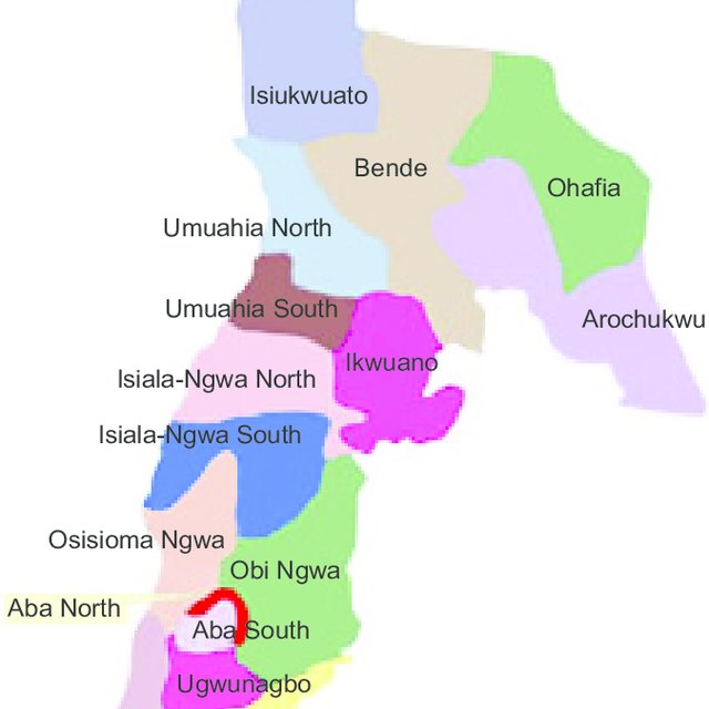
This article covers a list of the local government areas located in Abia state, read on below:
Aba North
Aba North is a Local Government Area of Abia State, located in the city of Aba. The postal code is 450
Aba South
The headquarters of Aba South is in the city of Aba. The local government has a population of 423,852 as recorded in the 2006 census. The postal code is 450
Arochukwu
Arochukwu is sometimes referred to as Arochuku or Aro-Okigbo. This is the third-largest city in Abia State (after Aba and Umuahia, the capital). Arochukwu is the homeland to the Igbo subgroup, the Aro people. Arochukwu comprises 19 villages with an overall leader called Eze Aro. Arochukwu is also a major historic town in Igbo land. This is because it was one of the cities in the Southern protectorate targeted by the British colonial government. Several historic tourist sites exist in the city. This includes the mystic Ibini Ukpabi shrine, the slave routes and other relics of the slave trade era which are frequently visited by tourists all around the world. Arochukwu is also in the food belt of Abia state where most of the staple foods are produced. This makes the town an important city in Abia state
Bende
Bende is a Local Government Area with headquarters located in Bende Community.
Ikwuano
The headquarters of Ikwuano Local Government Area is in Isiala Oboro.
Ikwuano LGA is among the local government areas that were created by the General Ibrahim Babangida’s Administration on 27 August 1991. This happened when General Ibrahim Babangida’s Administration created Abia State from the old Imo State. Ikwuano LGA was carved out of the old Ikwuano-Umuahia Local Government Area. It is one of the five LGAs that makeup Abia Central Senatorial District.
The vegetation of Ikwuano is a predominantly lowland rainforest, which makes it suitable for planting. Ikwuano is also the location of The Michael Okpara University of Agriculture Umudike, The National Crop Research Institute, as well as the prestigious Government College Umuahia. Ikwuano LGA is known for its agricultural activities (farming). The major crops cultivated here are palm oil/carnal, cocoa cassava, yam, broom, basket, etc.
Isiala Ngwa North
Isiala Ngwa North is a Local Government Area of Abia State, Nigeria. Its headquarters are in the town of Okpuala- Ngwa. It has an area of 283 km² and a population of 153,734 as recorded in the 2006 census. The postal code of the area is 451.
Isiala Ngwa South
Isiala Ngwa South has its headquarters in the town of Omoba.
Isuikwuato
Isuikwuato is a local government area in Abia State with an estimated population of over 50,000 people. Isuikwuato is blessed with natural resources such as iron ore and kaolin. Oil lines also flow through Isuikwuato. The major cash crops in Isuikwuato are palm oil and cassava.
Obingwa
Obingwa has its headquarters are in the town of Mgboko. The town has a population of 181,439 as recorded in the 2006 census. The postal code of the area is 453
Ohafia
Ohafia is a town located in the Ohafia local government area (LGA) in Abia State, Nigeria. It is an Igbo speaking region. Ohafia also houses the third largest military base in Nigeria called Goodluck Jonathan Barracks. The headquarters of the newly established 14 Brigade and 145 Battalion office complex is also located in Ohafia.
Osisioma Ngwa
The headquarters of Osisioma Ngwa are located in Osisioma town. Osisioma has a population of 219,632 as recorded in the 2006 census data of Nigeria.
Ugwunagbo
Ugwunagbo is a local government area of Abia State. Ugwunagbo has a population of 97,710 as recorded in the 2011 census. It is a suburb of Aba. Ugwunagbo is largely an agricultural town. The people depend solely on farming. The people of Ugwunagbo supply farm products such as yam, maize, cocoa, and palm oil to Aba and its environs. Ugwunagbo also has little deposit of crude oil.
Ukwa East
Ukwa East is a Local Government Area of Abia State. Its headquarters are in the town of Akwete. Ukwa East has a population of 58,865 at the 2006 census. The town has 11 political wards as recognised by the Independent National Electoral Commission (INEC),
Ukwa West
Ukwa West is a Local Government Area in Abia State with a population of 88,555 as recorded in the 2006 census. Its headquarters is in the town of Oke Ikpe. The postal code of the area is 452. Ukwa West is the only crude oil-producing area in Abia state.
Umuahia North
The headquarters of Umuahia North are in the city of Umuahia. It has a population of 220,660 as recorded in the 2006 census. The postal code of the area is 440.
Umuahia South
The headquarters of Umuahia South Local Government Area is at Apumiri in Ubakala. It has a population of 138,570 as recorded in the 2006 census. The postal code of the area is 440
Umunneochi
Umunneochi is also called Nneochi. The major occupation of the Umunneochi people includes agriculture, trading and mining. The population in Nneochi is 163,928, according to the 2006 Nigeria National Census. The postal code of the area is 441