Kaduna State is one of the 36th state of the Federal Republic of Nigeria. It is located in the north-western part of the country. It derives its name from its capital, Kaduna. This is why the state is usually referred to as Kaduna state, in order to distinguish the two. It is the third most populated state in the country and the 4th largest by land area. Kaduna, the state capital used to be the capital city of the British protectorate of Northern Nigeria region
The word Kaduna is reported to be a corruption of the Hausa word ‘”Kada’ which ‘crocodile’ while its plural form is “Kadduna” for crocodiles. There used to be many crocodiles in the river Kaduna. Some other version of the etymology of the name links it to the Gbagyi word or name ‘Odna’ for the Kaduna river. The symbol for the state is that of a crocodile. This article covers a list of local government areas located in Kaduna state.
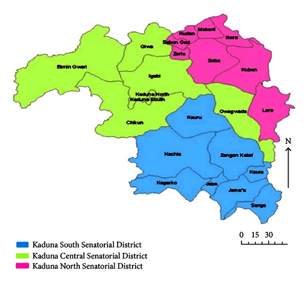
List of Local Governments in Kaduna State
Read on below:
Birnin Gwari
The headquarters of Birnin Gwari is in the town of Birnin Gwari. According to the 2006 population census, the area has a population of 252,363.
Chikun
Chikun is located in the southern part of Kaduna State. According to the 2006 census, the area has a population of 372,272 people. Its headquarters is in the town of Kujama. The Local Government Area derives its name from a Gbagyi village named Chikun, located in the South-Eastern part of Kujama.
Giwa
Giwa Local Government area was created on the 15th of September 1991, by the then president, General Ibrahim Badamasi Babangida. The local government was carved out of Igabi Local Government Area of Kaduna State. It is located in the North-Western part of Kaduna State. Its headquarters are in the town of Giwa. According to the 2006 census, Giwa LGA has a population of 286,427.
Igabi
Rigasa ward under Igabi LGA is one of the most populated wards in Nigeria. Research by the dRPC in Nigeria has shown that Igabi was founded by a man from Kukawa in Borno state. This man was a Qur’anic scholar who settled in order to teach the Qur’an and Islamic studies to the Hausa people who came to the northeast in search of Islamic religious knowledge. The curent capital of Igabi is Turunku.
Ikara
Ikawa is both a town and local government area in Kaduna State. The main occupation of the inhabitants of Ikara local government is farming and cattle rearing.
Jaba
Jaba is close to the Jos Plateau region and Abuja. Jaba was created on the 27th of August 1991. It was carved out from Jema’a Local Government. The capital of Jaba is in the town of Kwoi. It derives its name from Jaba, a local Hausa word used to describe the Ham people who are major inhabitants of the local government. Although the Ham people claim the word Jaba is derogatory.
Jema’a (Ajemaa)
Jema’a, also known as Ajemaa has its headquarters at Kafanchan. According to the 2006 census, It has a population of 278,202. The postal code of the area is 801.
Kachia
Its headquarters are in the town of Kachia. According to the 2006 census, Kachia has a population of 252,568.
Kaduna North
Kaduna North is often referred to as the pioneer local government in Kaduna state. It is the oldest local government in the state. Its headquarters is in the town of Doka. It is also the capital of Kaduna state.
Kaduna South
Its headquarters is in the town of Makera.
Kaduna State
Kagarko (also known as Wogon).
Its headquarters are in the town of Kagarko. According to the 2006 census, it has a population of 239,058.
Kajuru
Its headquarters is in the town of Kajuru (Ajure). It was carved out of Chikun Local Government Area in March 1997 by the military administration of Gen. Sani Abacha. When it was first created, it comprised of only two traditional districts, Kajuru and Kufana. Additional districts were later created, bringing the number to 14 districts
Watyap
The Hausa name for Watyap is Kaura. It is both a town and a Local Government Area, located in the southern part of Kaduna State. Its headquarters are in the town of Kaura
Kauru
It is located in the southern part of Kaduna State. Its headquarters are in the town of Kauru.
Kubau Local Government Area
It was created on the 2nd of November, 1995, during the military rule of General Sani Abacha. It was carved out from the present Ikara Local Government Area.
Kudan
Its headquarters are in the town of Hunkuyi. According to the 2006 census, Kudan has a population of 138,992 people.
Lere
Lere is both a town and local Government Area, located in the southern part of Kaduna State. It is the headquarters of the Lere Emirate. Lere town and its environs has an estimated population of about 93,290 as at the year 2016. Its headquarters are in the town of Saminaka.
Makarfi
Its headquarters are in the town of Makarfi. According to the 2006 census, Makarfi has a population of 146,259. The major economic activity of the Makarfi local government is agriculture.
Sabon Gari (Sabon-Gari Zaria)
This LGA is also a neighbourhood of Zaria City. It is also a district of Zazzau Emirate Council.
Sanga (also Igbunbu)
Its headquarters is in the town of Gbantu. According to the 2006 census, Sanga has a population of 151,485.
Soba
Its headquarters is in the town of Maigama.
Zangon Kataf
Its headquarters is in the town of Zonkwa.
Zaria
Zaria is a major and popular city in Kaduna State. It is also a Local Government Area. It used to be called Zazzau. It is a historical city as it is one of the original seven Hausa city-states. Zaria is home to one of Nigeria’s largest university today, Ahmadu Bello University.
According to the 2006 population census, Zaria has an estimated population of 408,198 people. It is home to the Zazzau Emirate.