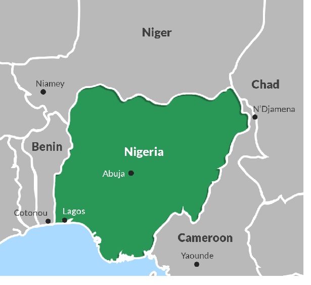
Nigeria is a country located on the Western Coast of the African Continent. With diverse ecological and climate features, the country shares both land and maritime boundaries with several countries. Land borders of judicially enforced demarcation lines between Sovereign nations with Nigeria include the Republic of Niger to the North, the Republic of Cameroon and Chad to East Chad, and the Gulf of Guinea of the Atlantic on the South. The Republic of Benin is to the West of Nigeria.
This is a list of land borders in Nigeria:
-
Zamfara – Republic of Niger Land Border
The Republic of Niger borders Zamfara State. The Shinkafi Local Government Area of Zamfara State borders with the Republic of Niger to the north.
-
Adamawa – Republic of Cameroon Land Border
Adamawa State is bordered by the Northern-Cameroon community of Garoua, to the east.
-
Borno – Republic of Niger Land Border
Borno is a northern state in Nigeria that shares boundaries with three countries, that is, Chad, the Republic of Nigeria, and the Republic of Benin; making it the only state in Nigeria with that characteristic. Borno State is bordered to the East by the Republic of Niger. Bosso village of the Diffa region of Niger Republic is the border settlement demarcating Borno State from the Niger Republic.
-
Jigawa – Republic of Niger Land Border
Jigawa is a Northwestern State in Nigeria sharing an international border with Niger to the north. The Zinder Region of the Republic of Niger is the border town that demarcates the Niger Republic from Jigawa State.
-
Cross River – Republic of Cameroon Border
Cross River is a state located in the southern part of Nigeria, sharing an international boundary with the Republic of Cameron. The eastern side of Cross Rivers State is bordered by the Republic of Cameroon. The demarcation between Mfun, Etung Local Government Area, and Cameroon is Manyu River in Mamfe, Republic of Cameroon. Though it is not a land border, there exists a suspension bridge built in 1948 at the Mfum border station that connects Nigeria with the Ekok village of the Republic of Cameroon, making it an official border crossing point.
-
Ogun – Republic of Benin Land Border
Ogun State is a South Western of Nigeria that borders the Republic of Benin to the West. Several border settlements exist along the Niger-Benin land border such as Igbofoki Community in Yewa North Local Government Area and the Idiroko village of Ipokia Local Government Area of Ogun State, serves as crossings into the Republic of Benin, with the latter being recognized as an official border crossing point since the 1960s.
-
Sokoto – Republic of Niger Land Border
Sokoto shares an international boundary with the Republic of Niger. The location of the Niger Republic is to the north of the State of Sokoto. The arid region of Sokoto State merges with the desert of Dosso Region of the Republic of Niger.
-
Kebbi – Republic of Niger Land Border
Kebbi State is bounded by Dosso Region of the Republic of Niger to the northwest.
-
Kwara – Republic of Benin Land Border
This is one of the land border boundaries in Nigeria. Chikanda border town of Baruten Local Government Area, Kwara State borders with Ndali, a town in Nikki Province of the Republic of Benin.
-
Borno – Republic of Cameroon Land Border
The land border that separates Borno State from the Republic of Cameroon is the Banki town of Borno State that is bounded by the Achimide community in the Far North Province of the Republic of Cameroon.
-
Oyo – Republic of Benin Land Border
Oyo State is in the southwestern region of Nigeria. The State of Oyo shares an international boundary with the Republic of Benin to the southwest. Atisbo Local Government Area is the border town that shares boundaries with the Republic of Benin.
-
Benue – Republic of Cameroon Land Border
Benue is a state located in the North-Central part of Nigeria that shares an international boundary with the Republic of Cameroon to the South – East.
-
Yobe – Republic of Niger Land Border
The northeastern State of Yobe shares an international land border with the Republic of Niger. Machina Logal Government Area of Yobe State is bounded in the north by the Diffa and Zinder Regions of the Republic of Niger.
-
Sokoto – Republic of Niger Land Border
Sokoto State and the Republic of Niger share international boundaries. Illela Local Government Area of Sokoto State has the Konni Region of the Republic of Niger to the north.
-
Enugu – Republic of Cameroon Land Border
Enugu State links with the Bamenda City of the Republic of Cameroon through the 443km Enugu-Bamenda Highway.
-
Lagos – Republic of Benin Land Border
The Seme border in the Badagry West Local Council Development Area of Lagos is a recognized border-crossing point for the movement of goods and people between Nigeria and the Republic of Benin. A coastal road from Badagry, Lagos links the City of Cotonou in the Republic of Benin.
Conclusion
Boundaries between countries exist in several ways ranging from natural and physical boundaries which present varying degrees of obstruction of communication and transport, examples such as mountain ranges, rivers, lakes and forests, to landscape boundaries that form as a result of a mixture of political and natural borders such as the borders that delineate between Sovereign states, granting complete authority which cannot be impeded by other governments within its border recognized by the international community.
Aside from the borders, Nigeria shares with the Republic of Niger, the Chad Republic, the Republic of Cameroon, and the Benin Republic, the following Sovereign States share maritime boundaries with Nigeria which include, Equatorial Guinea, Sao Tome and Principe, Ghana, Benin Republic, and the Republic of Cameroon. The land borders are crucial to the economy of Nigeria and bordering the Sovereign States as they facilitate commerce and provide foreign exchange, as well movement of persons between the countries. To guard against the illegal entry and exit of persons as well as smuggled goods, recognized entry points are established to manage the movement of goods and people through the boundaries.